
Mood:
Now Playing: So this is the Katy Trail!
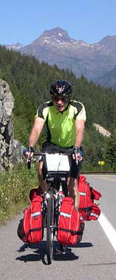
I had never heard of the Katy Trail until two friends, Brent and Linda Hunter, spent a week last year riding it. It has a certain mystique, but the biggest thing in its favor, in my mind, is the fact that it is 225 miles long. Although drivers have been ultra-courteous, not having to deal with them for a few days is something to look forward to. One other big advantage is that railroads try to not have their grade (angle of incline/decline) not exceed 2%. Thus, for a short time anyway, I won't have those steep hills to climb. Likewise I won't have steep hills to descend, but that is a tradoff that I can comfortably live with.
This was going to be another scorcher, so I listened to Karen's advice and started early. By 7 AM, having re-conquered the Country Kitchen Restaurant, I went to the Trailhead. Normally I have a good sense of direction but it was lacking this morning. When I got to the trail, it went both directions. I was sure that to the left was east, but the sun was rising from the other direction, so that the way I went.
Apparently, the Trail is mostly in use on weekends. This day, it was quiet. The railroad stopped running in 1986, and this gave trees plenty of time to grow alongside the railroad bed, forming a canopy. Almost, at times, a tunnel. For this day, at least, the countryside would be mostly obscured by the close vegetation. But this is a birder's paradise. Cardinals galore. I heard them long before they became active. There were some flycatchers on the powerline. An unseen wren gurgled its bubbly call from a bush as I rode past. A pileated woodpecker took flight. A large brown bird took flight up the path. The canopy kept it contained and it landed up a ways, then took off again as I neared. At first I thought of a type of heron, but then thought it might be a great horned owl. Still it was so big, it might have been some type of eagle. I don't know. But the birds were fun to watch the whole day.
By 9 AM, it was time to eat again. I exited into a town called Windsor, and had my second breakfast of the day (got to get that weight back that I lost earlier). It came to me that the real eye candy of this day was going to be the towns, not the Trail. These towns were all small but in a good way. they had character and were well maintained. It was like a step back in time, and each town had its own history.
In Sedalia I had lunch. It seemed that I was drinking more than eating. Probably a reaction to the heat, even though I didn't feel dehydrated. Put a tall glass of iced tea in front of me, and it disappeared quickly.
If you have ever had the experience of driving a car, then hitting a some black ice, and have your car suddenly fishtail as you fight for control, you will identify with what happened today. The trail itself is not paved. It is finely crushed limestone, and is remarkably good to ride on. Unfortunately, there was a short stretch, probably less than 100 feet, where some new limestone had been spread but not rolled. When I rode into it, there was no traction and the bike suddenly started fishtailing as I fought for control. I'm surprised that they didn't put up a warning sign.
When I was reading up on the Katy Trail, I gathered the impression that the railroad made these towns viable and that they died or were dying until the rail-trail was created. This sort of thinking reminds me of the three blind men who each touched a different part of an elephant (the trunk, the tail and the side) and described the animal, all woefully wrong, based upon what they were touching. My impression of these towns was equally wrong. They were viable before the rail-trail was put in, and it is just a very minor part of the local economy. As a side point, the Katy Trail is actually a Missouri Sate Park. Probably one of its larger ones, even though it is narrow.
The question that needed answering is in what town would I stay tonight? The Trail is 225 miles long, then I have another 25 miles with Diana Olesevich into St. Louis, and I have to complete it in four days. Since I wanted to lessen the risk of being late to meet Diana on Thursday, it would need to be the shortest day. Therefore today would need to be a longer day, depending on where the towns landed. I decided to stay tonight in Boonville, a nice town 72 miles down the trail. It is also where the Katy Trail meets, and will follow to its end, the Missouri River. That leaves 153 miles to the eastern trailhead. If I can 120-130 miles in the next two days, then that would leave only 23-33 miles left to the trailhead.
Of course, weather may have something to say about it. The forecast for the next several days is scattered thunderstorms, so who knows what will happen. All the more reason to do more miles earlier. The cold front which is causing the weather changes will also drop the temperatures a bit. Tomorrow's high will be 92 but the following two days will be in the low 80's.
Who knows what tomorrow will bring? We will find out then, and respond accordingly.
Will McMahan
Updated: Wednesday, 23 July 2008 6:29 PM PDT
Post Comment | View Comments (1) | Permalink | Share This Post